
REQUIREMENTS
- Hiking Boots – Good outdoors snickers should do fine.
- Water Proof Clothes – a Poncho and synthetic trousers will do fine in the rainy season.
- Thermo/Breathable Top – This should be light enough but should not absorb sweat.
- Sports trousers men or Tights for Ladies – need to be comfortable for a workout.
- Drinking water – At least 3 litres if you weigh over 50kgs
- Snacks – This can be biscuit, Juice, crisps, chocolate or anything that you enjoy munching.
- Back pack – For carrying your Items during the trek. If you can find one made of synthetic material since its water resistant.
- Plastic bag (Paper Bag) – For putting in your Litter e.g. empty bottles and also for carrying Wet clothes.
- Climbing stick – a light stick will do. You can purchase one from sports shop.
- Money – Entry fee Ksh 350 for Citizens, Kshs 700 for Residents and USD $30 for Non-Residents. Children pay a lower rate.
- Short toe nails.
- Have a good Breakfast
ABOUT THE MOUNTAIN
The Oldonyo Sabuk mountain is also known as Kilimambogo or Buffalo mountain. The mountain stands at 2,145m above sea level and is at the heart of the Ol Donyo Sabuk National Park which has a very rich history. The national park is situated in a very large farm which belonged to Lord William Northrup Macmillan, an American game hunter who settled in Kenya in 1901, during the colonial era. Macmillan was buried on the mountain together with his wife and his dog.
DIRECTIONS
The mountain is located about 70 kilometers from Nairobi off the Thika-Garissa Road and 15 kilometers from Thika town. To get there, use Thika Road until you get to the Thika Turn off that takes you into Thika Town. Take Garissa Road and go past Thika town. After driving for about 18km, you will get to a junction with a KWS sign on the right indication directions to the mountain. Take this turn and at the next junction about 1km down this earth road, turn left and drive until Ol Donyo Sabuk Town, where you take another right turn to the KWS Gate 2km from this town.
THE CLIMB
This is a very popular hike and you can therefore expect to meet very many people on any given weekend. The hike is estimated to take about 4 hours (round trip) if you use the footpaths which are a shortcut. We had also been advised by a friend who has been to the mountain severally that one does not require a guide (basically an armed Park Ranger) if you arrive in the earlier part of the day. However, take note that should you start this hike late and therefore risk the chance of not finishing before dusk, it is best to have a guide for security purposes. Remember this mountain is full of buffaloes although you are unlikely to spot them during the day like in our case. However, their feces are a constant reminder of their presence in the mountain. Having a guide is however based on your preference and as we noted during our climb, many groups did take a guide.

The hike up this mountain is relatively straightforward. There is an all-weather road which is passable by vehicles that leads from the station all the way to the top. The road steadily climbs up with a low gradient and only gets steep about 4km to the top and hence people of low fitness can do this climb. For those seeking a challenge, there is a well-defined footpath that starts just after the KWS station and cuts across the forest going up and later joins the main road at almost 6km away from the top. This footpath is a short-cut and hence takes a shorter time to go up – approximately 2 hours going up and a similar time going down. I’m not certain how much longer it would take while using the road but my guess is about 1 hour longer. However, the footpath makes the hike much more interesting so it’s definitely the best route to take.
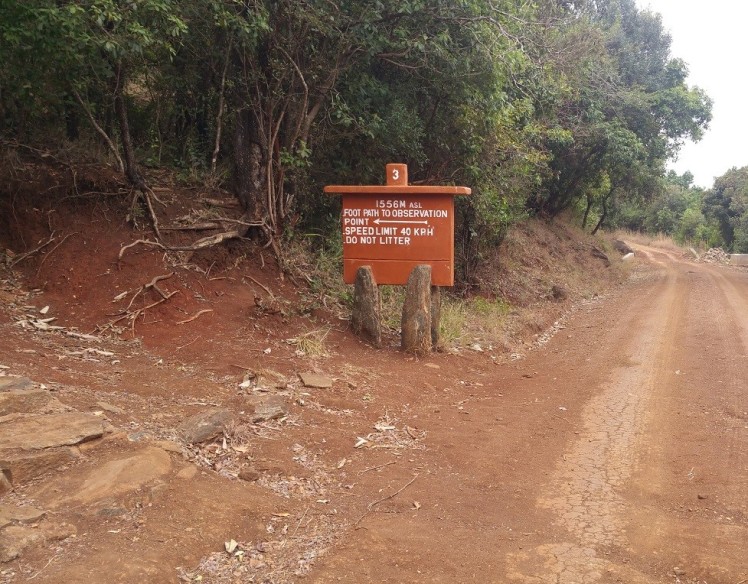
We started our journey to Oldonyo quite early, at about 7.30am. Once we got to the KWS station, we quickly made our payment, parked the vehicle and got ready for the climb. A large group of people was leaving the station to begin their climb just as we were arriving. After a brief chat with the KWS officers at the station to get directions since we were not getting a guide, we began our hike. As mentioned earlier, the footpath begins a few meters after the KWS station. It is well marked and so is was no chance of getting lost. Actually, this mountain is so well marked with big and beautiful signs that there is absolutely no chance of getting lost. This must be one of the best marked places in Kenya. The KWS team here has done an excellent job – round of Applause ;-).


The first part of the footpath is a rocky path which is easily passable. This path is relatively steep and we were easily able to maintain a rapid tempo. It took us about 20 minutes to complete this first part of the footpath. The footpath ends on the all-weather road where you walk for a few meters and then branch off the road into the 2nd part of the footpath. Again, this is very clearly marked.
This 2nd part of the footpath is where the cracks of the matter is. This part is extremely steep and very rocky. Within a few minutes, people were already huffing and puffing their way up. However, I’m extremely glad to say that thanks to all the training and practice, we took on this challenge extremely well and only rested twice and only for a couple of minutes. It took us about 25 – 30 minutes to complete this 2nd part of the footpath. It is advisable to wear comfortable clothes and good boots especially because of this part of the hike which is very rocky and may require a bit of gymnastics getting up. Going down can also be quite tricky for those who are like me (afraid of falling) because a part of this path has lose soil and one can easily lose their footing. Interestingly, a man passed us on his way up, running! I have heard that this mountain is used for training and I can understand why, it is definitely a perfect place to train.


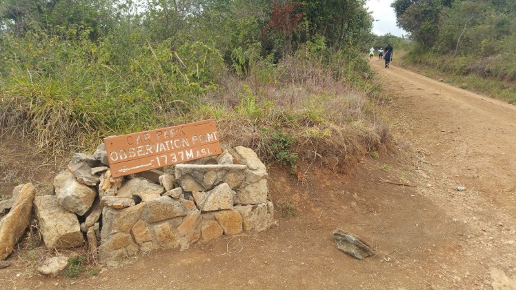
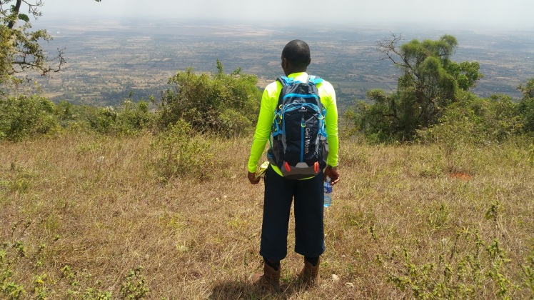
The footpath ended up back at the all-weather road. From this point, the rest of the hike to the summit is on this main road. A few meters after getting back to the road, we arrived at the picturesque point known as the observation point. This point is about 5.6kms away from the summit and is at 1737m above sea level (408m below the summit). The view of the areas surrounding the mountain at this point is amazing, probably the best view on the mountain since the summit does not really boast of a great view. From this point, you can see the farmlands, towns and homesteads and even a few dams and rivers in the surrounding areas. We stopped at this place to catch our breaths and take some photos as well as hydrate. Being in this place and looking down somewhat felt like being in a low-flying plane.

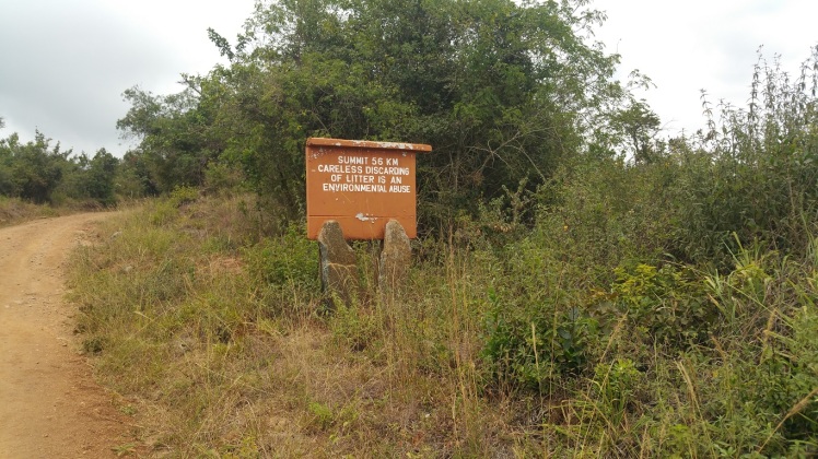
After the short break, we started our hike up on the road again. As mentioned earlier, this mountain is very well marked. The road has signs after every 1km which is a splendid idea as it played its part of encouraging me to keep a fast pace to get to the summit within the 2 hours’ average time. It’s also really useful as the road has many turns and one can’t quite tell how far you really are to the top. Being the competitive person that I am, I made sure that I kept a very fast pace up this road to keep the time. So you can bet that I didn’t take the photos, a very helpful person had to stop and take these photos and then run to keep up with the rest of us, God bless his soul:). We actually agreed to not even stop at Macmillan’s grave on our way up and instead do it on our way down. It is worth noting that the last stretch of this road to the top becomes quite steep – for someone who is not fit, its very steep – for about 4km.
SUMMIT
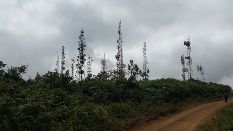
I think the most disappointing part of this hike was the summit. There is really nothing extraordinary about it. At the summit, there are a lot of masts which have been put up by media stations, Police and Mobile Network Operators. As I was busy dealing with my disappointment of the lack of an exciting summit (although I really can’t say what an exciting summit is), one of my fellow hikers was busy looking at the masts and saying how some had not been in use for a very long time. Anyway, I suppose that’s irrelevant. There are also a few houses at the summit, probably belonging to wardens.
The Oldonyo Sabuk summit is at 2145m above sea level, definitely below some of the heights I have scaled but still a very good hike and a must climb. We took the time to rest, enjoy some snacks and take photos at the summit. Remember the runner who I mentioned passed us at the footpath? Well, we found him here stretching and doing exercises. How I wish I could be that serious with my exercising. One thing to watch out for are ants. The summit has humongous ants whose bites can make a grown man cry. Three of them found their way into my upper body and decided to make a feast out of me. I almost undressed on that mountain, the pain was real 😥

 ter spending about 20 minutes at the summit, we began our descent down. It was now about 12.40pm. On our way down, we met with a variety of groups of people on their way up, from families to youngsters having fun. The roads were literally full of people. I suppose most hikers start the hike after mid-morning. The most hilarious part was seeing the youngsters going up the mountain, some dressed in mini-skirts and armed with selfie sticks but with no water or snacks. It made me feel way too old and serious, what with my backpack full of water and snacks. We decided to do some sightseeing on our way down with our first stop at Macmillan’s grave. The stone covering the grave is extremely large. We got to learn from a guide that Macmillan’s wish had been to be buried at the summit. However, the truck delivering the stone apparently broke down and hence the reason he was buried below the summit. During that time, there was no well-defined road on the mountain and the area was very swampy hence the challenge doing such a trip. The stone also has cracks at the corner apparently from thieves who had tried to pry open the grave unsuccessfully I think. Macmillan died in 1925 at the age of 53 years while his wife Lucy died in 1958. Lucy was buried next to her husband together with their maid and their dog.

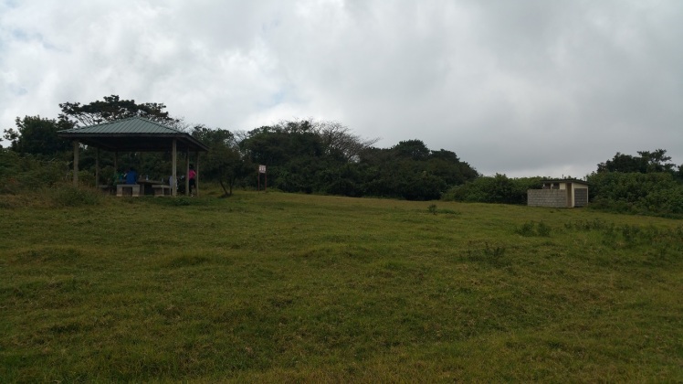
Further down the road, we came across a sign pointing towards a picnic site. The mountain has several picnic sites. We decided to explore this as well, being the adventurous people that we are. After walking through a path filled with overgrown vegetation for about 5 minutes and almost giving up, the path finally cleared out to a picnic site that had an amazing view of the other side of the mountain. The view was totally worth the walk.

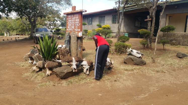
Going down the mountain along the footpath was a lot easier than going up. However, the descent presents a new challenge of lose soil which can easily make one to fall. I would not want to be there during the rainy season. Once we got back to the station, we took note of some huge skulls that we had not seen earlier at arrival – Guess we were to eager to start the hike. After studying them for a while, my friend decided that some of the skulls were of mammoths, dinosaurs and dragons from ancient ages (he should have his head checked, clearly). A guy passing by however corrected our naivety (or is it our sick sense of humor 😆 ) and told us that the ‘dragon’ skulls were actually hippo skulls. So much for fantasies 😯
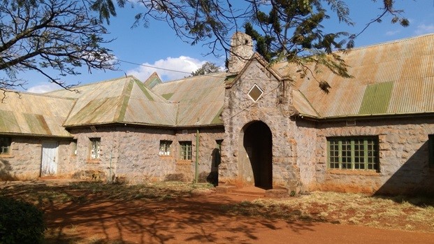
MACMILLAN CASTLE
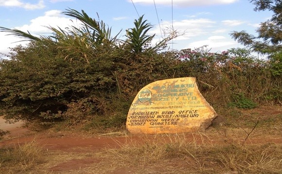
We decided to take advantage of the day and make a trip to the Macmillan Castle. The castle is located outside the park past Oldonyo Sabuk town. However, a similar house which Macmillan built for his farm manager and which is much smaller than the castle is situated in the park. We didn’t get to check this out as it meant walking back into the park and we were too tired for this, not to mention the fact that our boots were already off and there was no way we were putting them back on. To get to the castle, we had to exit the park and get back to Oldonyo Sabuk town/market. Once you get off the dirt road and get onto the main road, you take a right and drive down several kilometers till the end of the pineapple plantation. There is a sign on the right that directs one to the castle. Part of the castle is now used as offices for Muka Mukuu Farmers Co-operative Society Ltd which runs the surrounding pineapple farms.
Visiting the castle is a must for every Kenyan. For history buffs like me, this place is like 7th heaven because of its rich history. The castle is single storied with high ceilings and humongous rooms. Even his bathroom was gigantic. Macmillan hosted important historical figures like former American President Theodore Roosevelt and British Prime Minister, Sir Winston Churchill in this castle and the rooms they stayed in are even marked. It gave me goosebumps just thinking that I was standing in rooms that such powerful people inhabited, and right here in Kenya!! The castle’s beautiful floors, walls and ceilings are still in good condition despite being over a century old, no doubt due to the use of world class building material. The ceilings, doors and roof beams are apparently made from oak wood imported from the Scandinavian countries. This castle is a wonder to behold, I kid you not.
We arrived past visiting hours but managed to convince the wonderful gentlemen who manage the castle to allow us in and give us a tour. There is no charge to view and tour it. The most amazing part of this castle is the underground tunnels which Macmillan built for safety purposes. These tunnels were also used as a prison during the colonial period (World War 2, I believe). The Italian Governor during the war was held in these bunkers as a prisoner. These bunkers were definitely the most exciting part of the trip for me, I was eerily transported to another age, just trying to imagine war prisoners held here in a lying position throughout the entire time. The prisons were only a few inches high and the prisoners had to crawl inside them. Pathways have however been dugout to enable visitors to walk through the maze. We walked through the entire tunnel maze and to be honest, I really did not want to leave. So much history!
Once our tour was complete, we were invited into the office to sign the visitors book. The gentlemen who take care of the castle told us of their unfortunate futile efforts to try and get funds to revamp the castle and create some exciting activities to attract visitors. They have very ambitious but brilliant plans to create a zip line running from the mountain down to the castle. However, they lack the funds to do that. This is where the government should come in (Tunaomba Serikali isaidie), that is why we pay taxes, to fund such projects that are rich with history and will enthrall generations to come. I will definitely be going back to this castle someday. 1 visit is just not enough!!!

One thought on “Ol Donyo Sabuk (Kilimambogo)”